본문 내용 바로가기 대메뉴 바로가기

News

end

Search

  • 메인으로

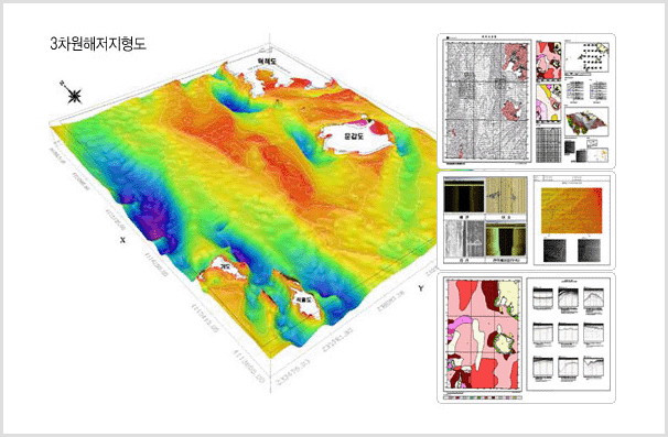
Coastal Waters Survey Purpose

The coastal waters are areas where land and the sea coexist ranging from regions registered in the land register to the outer limits of the territorial waters. The coastal waters survey is intended to investigate the water depths of the coastal waters, rocks, coastlines, and shallow subsurfaces so as to provide basic data for coastal waters management and preservation, and to secure sea traffic safety.

Main Surveying

  • Inquire and survey the bottom topography, sea floor facilities and dangers of coastal waters.
  • Observe the tides and ocean currents of coastal waters.
  • Investigate potential places as ecological sanctuaries capable of self-purification.
  • Produce orifinal maps and establish submarine information database
    • 1 Tidal observation
    • 2 Tidal current observation
    • 3 Multi-beam survey
    • 4 Sea floor facility survey
    • 5 Geological survey
    • 6 Sub-bottom profiling
    • 7 Sea-bottom sediment survey

Track Records and Future Plans

  • 2010 : Completed a total of 1,657 km² of coastal waters in Mokpo, Gunsan, and Pohang.
  • 2011 : Completed approximately 2,301 km² of coastal waters in the southern part of the Yellow Sea and near Saemangeum.
  • 2012 : Completed the basic survey of coastal waters of 3,167 km² in total in the southern parts of Wando and Goheung.
  • 2013 : Completed the detailed survey of coastal waters of 1,500 km² in total near Goheung.
  • 2014 : Scheduled to conduct the detailed survey of coastal waters of approximately 1,200 km² near Wando.
3-D bathymetric chart

Expected Effect

  • This is the comprehensive information survey of coastal waters, designed to provide basic data to establish marine policies and revitalize relevant industries.
  • This is intended to provide information on locations of oil and gas pipelines, and submarine cables scattered in the coastal sea floor.
  • This is to provide relevant businesses with data about electronic navigational charts, the production of coastal area maps, and integrated coastal management and maintenance.
  • The acquisition of digitalized data on sea areas without marine surveying yet enables the provision of basic data on Korea’s coasts as a whole.